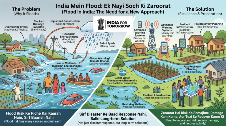

India mein flooding ek recurring disaster hai jo har saal homes, agriculture, roads, businesses, public services aur communities ko impact kar sakti hai. Lekin flood ko sirf heavy rainfall ka result samajhna India ke flood risk ki complete picture nahi deta.
Flood risk rainfall ke saath rivers, drainage capacity, urbanisation, land-use changes, wetlands, floodplains, infrastructure, water management, warning systems aur changing climate patterns se bhi connected hai. Isi wajah se flood management ka solution bhi sirf flood ke baad rescue aur relief tak limited nahi hona chahiye.
Aaj India ke liye zaroori question yeh hai ki kya hum floods ko har saal repeat hone wali unavoidable problem ke roop mein accept karenge, ya cities, villages, rivers aur water systems ko zyada flood-resilient banayenge?
India Mein Flooding Itni Serious Problem Kyun Hai?
India ka rainfall pattern highly seasonal hai. Kuch regions mein limited time ke andar intense rainfall ho sakti hai, jabki doosre periods mein water shortage ka pressure hota hai. Jab rainfall ki intensity drainage, river ya natural storage capacity se zyada ho jaati hai, flooding ka risk badh sakta hai.
Flood ka damage paani ke ghar mein enter karne tak restricted nahi hota. Ek major flood roads aur bridges ko damage kar sakta hai, crops ko destroy kar sakta hai, schools aur hospitals ki functioning disturb kar sakta hai aur drinking water ko contaminate kar sakta hai.
Electricity, communication, transport aur local businesses bhi affected ho sakte hain. Farmers aur daily-wage workers ke liye income loss recovery ko aur difficult bana sakta hai. Kuch families ko temporary displacement ka saamna bhi karna pad sakta hai.
Isliye flood ko ek simple water problem ke bajay water, infrastructure, livelihood, health, environment aur governance problem ke combination ke roop mein dekhna chahiye.
Flood Risk Ke Main Causes Kya Hain?
1. Heavy Rainfall
Short duration mein high-intensity rainfall rivers, drains aur natural water systems par sudden pressure create kar sakti hai. Rainfall ko control karna possible nahi hai, isliye flood planning ka focus water ke movement par hona chahiye.
Ek effective approach ko is chain ke through samjha ja sakta hai:
Rainfall → Runoff → Storage → Drainage → Safe Discharge
Agar water ko absorb, temporarily store ya safely discharge karne ki capacity insufficient ho, to flooding ka possibility increase hota hai.
2. Natural Drainage Ka Loss
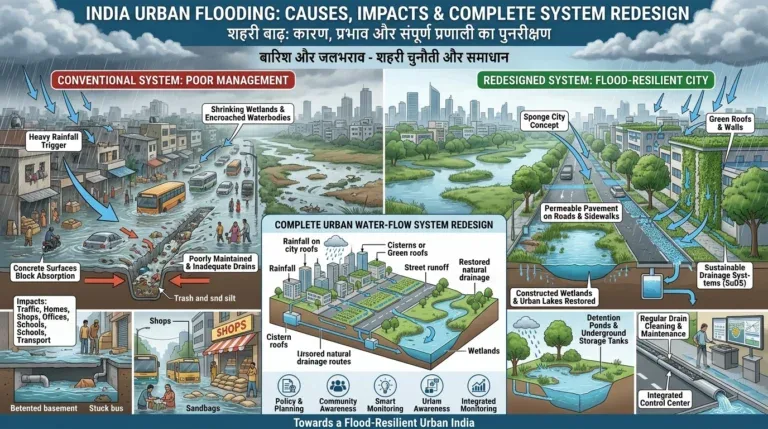
Urban development ke saath open land, ponds, wetlands aur natural channels concrete surfaces se replace ho sakte hain.
Concrete rainwater ko ground mein naturally absorb hone ka opportunity reduce karta hai. Isse surface runoff badhta hai aur rainfall ke baad water rapidly accumulate kar sakta hai.
Isi liye urban flood management mein sirf drains ki number increase karna sufficient nahi hai. Natural water-flow routes ko bhi identify aur protect karna zaroori hai.
3. Floodplains Mein Unplanned Construction
River ke nearby floodplain areas naturally high-water periods mein water ko accommodate karne mein important role play karte hain.
Agar flood-prone land par uncontrolled construction hoti hai, to floodwater ke movement aur temporary storage ke natural options reduce ho sakte hain. Saath hi human exposure bhi increase hota hai.
Flood risk ko urban planning aur construction decisions ka basic input banana zaroori hai.
4. Drainage Capacity
Urban flooding har baar extreme rainfall ki wajah se nahi hoti. Blocked drains, garbage, poor maintenance, undersized drainage networks, disconnected channels aur insufficient pumping capacity bhi waterlogging ko serious bana sakte hain.
Isliye drainage improvement ka matlab sirf new drains construct karna nahi hona chahiye.
City ke complete water-flow system ko samajhna zaroori hai:
Roof → Street → Local Drain → Main Drain → Water Body/River → Basin
Agar is chain mein kisi critical point par blockage ya capacity issue hai, to waterlogging ho sakti hai.
River Flood, Urban Flood Aur Flash Flood Mein Difference
Har flood ka behaviour same nahi hota.
River flood tab ho sakta hai jab river ka water level increase hokar surrounding areas ko affect kare.
Urban flood rainfall ke baad city ke stormwater aur drainage system ki capacity exceed hone par develop ho sakta hai.
Flash flood mein water flow bahut rapidly increase ho sakta hai, jiski wajah se available warning time limited ho sakta hai.
Coastal flooding cyclones, storm surges aur sea-level-related conditions se influenced ho sakti hai.
Different flood types ke liye different forecasting, planning aur emergency response systems ki zarurat hoti hai.
Climate Change Flood Risk Ko Kaise Affect Karta Hai?
Climate change flood risk ko more complex bana sakta hai. Changing rainfall patterns, extreme weather events, rising temperatures aur hydrological conditions different regions ke water risks ko influence kar sakte hain.
Lekin har individual flood ko sirf climate change se explain karna incomplete approach hoga.
Flood risk ko ek combined system ke roop mein dekhna better hai:
Weather + Geography + River System + Land Use + Infrastructure + Governance + Climate
Urbanisation aur climate-related changes jab ek saath interact karte hain, to vulnerable areas mein flood risk aur complicated ho sakta hai.
Assam Se India Kya Seekh Sakta Hai?
Assam flood management ke liye ek important example hai. Brahmaputra aur uski tributaries, seasonal rainfall, riverbank erosion aur floodplain settlements flood risk ko complex banate hain.
Flooding ke saath riverbank erosion bhi land, agriculture, houses aur infrastructure ko affect kar sakta hai.
Isliye river management ko sirf water-level control ke perspective se dekhna sufficient nahi hai. River behaviour, erosion, settlements aur basin-level water movement ko bhi consider karna chahiye.
River administrative boundaries ko follow nahi karti. Isi wajah se multiple districts, states, departments, researchers, engineers aur local communities ke beech coordination important hai.
India Flood Management Ko Kaise Improve Kar Sakta Hai?
Long-term flood management ko ek continuous cycle ki tarah develop kiya ja sakta hai:
Predict → Prevent → Prepare → Protect → Respond → Recover → Improve
Better Flood Forecasting
Early warning flood resilience ka important component hai.
Forecasting mein rainfall data, river levels, weather forecasts, satellite observations, ground sensors, historical flood records aur hydrological models ko combine kiya ja sakta hai.
Lekin sirf government dashboard par warning publish kar dena enough nahi hai.
Information affected communities tak right time par, simple language mein aur actionable instructions ke saath pahunchni chahiye.
Flood Risk Mapping
Cities, towns aur villages ke liye detailed flood-risk maps develop kiye ja sakte hain.
Mapping mein low-lying areas, flood-prone zones, drainage routes, ponds, wetlands, roads, hospitals, schools, shelters aur evacuation routes identify kiye ja sakte hain.
Risk maps ko regularly update karna bhi important hai kyunki urban development aur infrastructure changes flood behaviour ko alter kar sakte hain.
Natural Water Systems Protect Karna
Wetlands, lakes, ponds, rivers, floodplains, forests, groundwater recharge areas aur open spaces natural flood-management infrastructure ke roop mein important ho sakte hain.
Flood resilience ke liye engineered infrastructure aur natural systems ko complementary manner mein use kiya ja sakta hai.
Flood-Resilient Construction
Construction planning ke stage par kuch basic questions pooche jaane chahiye:
- Kya location flood-prone hai?
- Natural drainage route kahan hai?
- Rainwater safely kahan jayega?
- Groundwater recharge kaise hoga?
- Emergency vehicles ke liye access available hai?
- Evacuation possible hai?
- Nearby hospitals aur other critical infrastructure vulnerable hain?
Aise questions flood risk ko development planning ka part bana sakte hain.
Flood Management Mein Technology Ka Role
Technology flood management ko faster aur data-driven bana sakti hai.
Real-time water-level sensors rivers aur drains mein changing conditions monitor kar sakte hain. Rainfall, flow, drainage levels aur soil moisture jaise data bhi useful ho sakte hain.
Satellite imagery large areas mein flooding identify karne aur post-flood assessment mein support kar sakti hai.
AI aur machine-learning systems rainfall, river levels, terrain, land use, drainage aur historical flood records jaise inputs ke basis par flood-risk modelling ko support kar sakte hain.
Lekin AI ko human decision-making ka replacement nahi samajhna chahiye. Iska role decision-support system ka hona chahiye.
Technology ka basic principle simple hona chahiye:
Right Information → Right Person → Right Time → Right Action
Early Warning System Kaisa Hona Chahiye?
Flood warning technically accurate hone ke saath understandable bhi honi chahiye.
Affected citizens ko simple language mein bataya ja sakta hai ki risk kya hai, kya prepare karna hai aur kahan move karna hai.
Warning systems mein SMS, mobile alerts, local sirens, community volunteers aur local-language communication ko combine kiya ja sakta hai.
India Ke Liye Flood-Resilience Framework
India ke liye flood management ko eight-step framework ke through strengthen kiya ja sakta hai:
- Map — flood-prone locations identify karein.
- Understand — rainfall, rivers, drainage aur land use ke relationships samjhein.
- Measure — reliable flood data collect karein.
- Predict — historical aur real-time information se risk modelling karein.
- Prevent — wetlands, drainage aur natural storage protect karein.
- Prepare — warnings, shelters aur evacuation systems ready rakhein.
- Respond — government, emergency services aur communities ke roles define karein.
- Recover and Improve — reconstruction ke saath future risk reduce karein.
Flood Management Mein Kaun Kya Kar Sakta Hai?
Government planning, regulation, infrastructure, forecasting aur emergency response mein central role play karti hai.
Universities aur researchers hydrology, climate research, GIS mapping, flood modelling, AI, disaster management aur urban planning par kaam kar sakte hain.
Technology teams sensors, dashboards, mobile applications, mapping systems aur warning platforms develop kar sakti hain.
Industry resilient infrastructure, water technologies, logistics aur communication systems provide kar sakti hai.
Citizens bhi local flooding report karne, drains mein waste avoid karne, emergency instructions follow karne aur vulnerable neighbours ki help karne mein important role play kar sakte hain.
Conclusion: Flood Ko Stop Karna Nahi, Impact Ko Reduce Karna Hai
India mein floods ko completely eliminate karna realistic goal nahi hai. Lekin flood ke impact ko reduce karna, timely warning provide karna, critical services ko operational rakhna aur recovery ko faster banana possible hai.
Flood resilience ke liye India ko better data, better planning, stronger infrastructure, protected natural water systems, technology, early warning aur local participation ko ek connected framework mein lana hoga.
Har flood ke baad sirf yeh poochna enough nahi hai ki kitna damage hua.
Better question hai:
Humne kya seekha, aur next flood mein same damage ko kaise kam kiya ja sakta hai?
A resilient India ka objective flood-free India banana nahi hai. Objective ek aisa India banana hai jo flood ke risk ko samjhe, pehle se prepare ho, warning ko action mein convert kare aur disaster ke baad stronger recovery kare.
Frequently asked questions
Questions readers ask.
Heavy rainfall ke saath poor drainage, natural water systems ka loss, floodplain construction, land-use change, river overflow aur infrastructure limitations flood risk ko influence kar sakte hain.
Drainage maintenance, flood-risk mapping, natural drainage protection, wetlands conservation, better construction planning aur real-time monitoring urban flood risk ko reduce karne mein support kar sakte hain.
AI historical aur real-time data ko analyse karke flood-risk modelling aur decision support mein help kar sakta hai.
Iska matlab flood ko completely eliminate karna nahi, balki risk ko understand karke timely warning, preparedness, resilient infrastructure aur faster recovery develop karna hai.