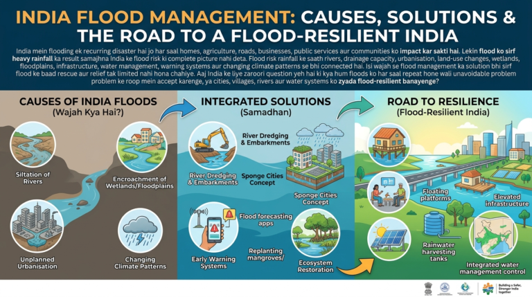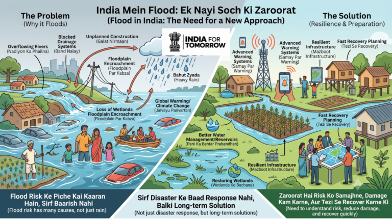
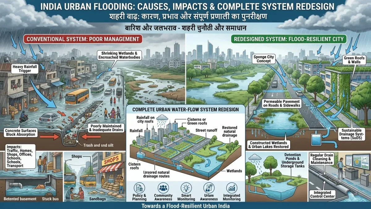
Barish ke baad city ki roads par paani bharna India ke kai urban areas mein familiar problem ban chuka hai. Kabhi rainfall kuch ghanton ke liye hoti hai, lekin uska impact traffic, homes, shops, offices, schools aur public transport par kai ghanton tak reh sakta hai.
Urban flooding ko dekhkar aksar first reaction hota hai ki “baarish bahut zyada thi.” Heavy rainfall definitely flooding ka ek important trigger ho sakta hai, lekin city mein flood risk ko sirf rainfall se explain karna incomplete hai.
Ek city rainwater ko kitni speed se absorb, store aur discharge kar sakti hai, uska direct relationship urban flood risk se hai.
Agar natural drainage routes disappear ho rahe hain, wetlands shrink ho rahe hain, open land concrete mein convert ho raha hai aur drainage network adequately maintained nahi hai, to rainfall ka water rapidly surface runoff mein convert ho sakta hai.
Isi liye urban flood management ka focus sirf bigger drains banane par nahi, balki complete urban water-flow system ko redesign aur manage karne par hona chahiye.
Urban Flooding Kya Hai?
Urban flooding tab ho sakti hai jab rainfall ke baad city ka stormwater drainage aur water-management system available water ko safely move nahi kar paata.
Yeh situation multiple reasons se develop ho sakti hai.
For example, drains undersized ho sakte hain, garbage ki wajah se blocked ho sakte hain, natural channels construction ke neeche aa sakte hain ya drainage network ke different sections properly connected nahi ho sakte.
Kuch areas mein pumping capacity bhi insufficient ho sakti hai.
Isliye urban flood ko ek single infrastructure failure nahi, balki interconnected system failure ke roop mein samajhna useful hai.
Concrete City Aur Rainwater Ka Relationship
Natural land rainfall ka ek portion absorb kar sakti hai. Lekin roads, parking areas, buildings aur other concrete surfaces water infiltration ko reduce kar sakte hain.
Result:
More Concrete → Less Absorption → More Runoff → Faster Water Accumulation
Agar same time par drainage network ki capacity limited hai, to waterlogging rapidly increase ho sakti hai.
Urban planning mein isi relationship ko seriously consider karna zaroori hai.
Ponds Aur Wetlands Itne Important Kyun Hain?
Ponds, wetlands, lakes aur open spaces sirf empty land nahi hote.
Natural water systems rainfall ke water ko temporarily hold, store ya slow karne mein role play kar sakte hain.
Agar aise areas ko fill karke construction kar di jaye, to city ka natural water-storage capacity reduce ho sakta hai.
Isliye urban flood resilience mein natural infrastructure ko engineered infrastructure ke equal planning consideration milna chahiye.
Drain Banana Enough Kyun Nahi Hai?
Flooding ka solution aksar “aur bade drains” ke roop mein discuss kiya jata hai.
Lekin ek drain tabhi effective hai jab complete drainage chain properly work kare.
Is chain ko simple way mein dekhein:
Roof → Street → Local Drain → Main Drain → Water Body/River → Basin
Agar roof se water street par aa raha hai lekin street drain blocked hai, problem wahi start ho sakti hai.
Agar local drain ka water main drain tak efficiently nahi pahunch raha, water accumulation continue ho sakta hai.
Agar main drainage network ke end par water body ya river mein discharge capacity limited hai, to upstream flooding ho sakti hai.
Isliye city drainage ko isolated pipes aur drains ke collection ke bajay connected water system ke roop mein manage karna chahiye.
Urban Flood Risk Mein Garbage Aur Maintenance Ka Role
Drainage infrastructure ka design important hai, lekin maintenance bhi equally important hai.
Blocked drains rainfall ke time water movement ko restrict kar sakte hain.
Garbage, silt aur other material drainage capacity ko reduce kar sakte hain.
Regular inspection aur cleaning ke bina even well-designed drainage network expected performance nahi de sakta.
Smart drainage management mein preventive maintenance ko emergency response se pehle place karna chahiye.
Flood-Risk Mapping Se Cities Ko Kya Benefit Ho Sakta Hai?
Har city ke liye flood-risk map develop karna useful step ho sakta hai.
Aise map mein identify kiya ja sakta hai:
- low-lying areas
- historical waterlogging locations
- flood-prone zones
- natural drainage routes
- ponds and wetlands
- important drains
- hospitals
- schools
- roads
- shelters
- evacuation routes
- critical infrastructure
Agar yeh information regularly updated rahe, to city planners ko development decisions mein flood risk consider karne mein help mil sakti hai.
Construction Se Pehle Flood Risk Check
New building ya infrastructure project approve karne se pehle kuch basic questions mandatory planning process ka part ho sakte hain.
Kya site flood-prone hai?
Natural drainage route kahan hai?
Rainwater safely kahan discharge hoga?
Kya construction downstream flooding increase kar sakti hai?
Emergency access available rahega?
Nearby hospital, school ya other critical infrastructure risk mein to nahi aayega?
Aise questions flood resilience ko project completion ke baad repair issue banne se pehle planning stage mein address kar sakte hain.
Smart City Ka Matlab Sirf Digital City Nahi
Smart city discussions mein digital services, connectivity aur technology par focus hota hai. Lekin flood resilience bhi smart urban planning ka important part hai.
Ek genuinely smart city ko pata hona chahiye:
- rainfall kitni ho rahi hai
- rivers aur drains ka water level kya hai
- kaunse areas waterlogged hain
- kaunse roads closed hain
- shelters kahan available hain
- evacuation routes kaunse hain
- kaunsi critical services vulnerable hain
Technology ka value tabhi hai jab data real-world action mein convert ho.
Sensors Urban Flood Management Ko Kaise Improve Kar Sakte Hain?
Water-level sensors critical drains aur water bodies mein real-time information collect kar sakte hain.
Rainfall sensors rainfall intensity ko monitor kar sakte hain.
Possible data points mein water level, rainfall, flow, drainage level aur soil moisture include kiye ja sakte hain.
Is information ko central platform par combine karke authorities ko early indication mil sakta hai ki kisi area mein risk increase ho raha hai.
Lekin sensors install karna final solution nahi hai.
Data ko interpret karna, threshold define karna, responsible teams ko alert bhejna aur field action lena bhi equally important hai.
AI Aur Flood Prediction
AI-based systems historical flood records aur real-time information ko analyse karke risk modelling ko support kar sakte hain.
Possible inputs:
Rainfall + River Levels + Terrain + Land Use + Drainage + Historical Flood Data + Weather Forecasts
AI future risk ke patterns identify karne mein useful ho sakta hai, lekin automated prediction ko blindly accept karna appropriate nahi hoga.
Local knowledge, engineering judgement aur ground verification ko technology ke saath integrate karna important hai.
AI ka best role decision-support system ka hai.
Satellite Data Ka Use
Satellite imagery large geographical areas ko monitor karne mein useful ho sakti hai.
Flood event ke baad satellite observations affected areas identify karne, flood extent understand karne aur changes track karne mein support provide kar sakti hain.
Is type ka data response agencies aur planners ko post-flood assessment ke liye useful information de sakta hai.
Early Warning Ka Real Meaning
Flood warning ka purpose sirf alert publish karna nahi hai.
A useful warning citizen ko batati hai:
- Risk kya hai?
- Risk kitni serious hai?
- Abhi kya action lena hai?
- Safe location kahan hai?
- Kis route se move karna hai?
Local language mein short aur clear instructions warning system ko more useful bana sakti hain.
SMS, mobile notifications, sirens, local volunteers aur community communication channels ko combine kiya ja sakta hai.
Public Flood Dashboard Kaise Useful Ho Sakta Hai?
Ek public flood dashboard par area-wise information provide ki ja sakti hai:
- current rainfall
- river level
- flood alerts
- affected areas
- road closures
- emergency shelters
- evacuation routes
- emergency contacts
Data unavailable ho to system ko clearly “Data unavailable” show karna chahiye. False precision public trust ko damage kar sakti hai.
Schools Aur Hospitals Ko Flood Planning Mein Priority Kyun Milni Chahiye?
Flood ke time hospitals aur schools critical facilities ban sakte hain.
Hospitals ko emergency situations mein operational rehna chahiye. Schools kuch situations mein emergency shelters ke roop mein use ho sakte hain.
Flood-prone areas mein critical facilities ke liye elevated electrical systems, backup power, safe drinking water, communication systems aur flood-safe access routes plan kiye ja sakte hain.
Urban Flood Resilience Ka Practical Model
Ek city apne flood management ko step-by-step strengthen kar sakti hai.
Step 1: Map
City ke flood-prone areas aur water-flow routes identify karein.
Step 2: Measure
Rainfall, water levels, waterlogging locations aur drainage capacity ka data collect karein.
Step 3: Protect
Ponds, wetlands, natural channels aur flood storage areas protect karein.
Step 4: Improve
Blocked, undersized ya disconnected drainage systems ko upgrade karein.
Step 5: Monitor
Sensors aur field inspections ke through critical locations monitor karein.
Step 6: Warn
Risk increase hone par local residents ko actionable alerts dein.
Step 7: Respond
Emergency teams, local bodies, volunteers aur citizens ke responsibilities clear rakhein.
Step 8: Learn
Har flood ke baad identify karein ki system mein failure kahan hua aur next event se pehle kya improve kiya ja sakta hai.
Citizens Ka Role Kya Hai?
Urban flood management sirf municipal bodies ki responsibility nahi hai.
Citizens drains mein waste na daal kar drainage system ki functioning support kar sakte hain.
Local waterlogging aur blocked drains report karna useful ho sakta hai.
Emergency warnings ko follow karna, vulnerable elderly people, children aur persons with disabilities ki help karna community resilience ko improve kar sakta hai.
Local communities flood-risk mapping mein bhi participate kar sakti hain kyunki residents ko ground-level water movement aur recurring problem locations ki practical knowledge hoti hai.
India Ke Cities Ke Liye Next Step
Future urban development ko flood risk ke saath integrate karna hoga.
New roads, buildings, housing projects aur commercial developments ko approve karte waqt rainwater movement aur downstream impact consider karna zaroori hai.
Natural water systems ko development ke obstacles ke bajay city infrastructure ka part samajhna hoga.
Flood management ka target sirf water ko jaldi city se bahar nikalna nahi hona chahiye. Kuch water ko safely store, absorb aur slow karna bhi equally important ho sakta hai.
Conclusion: Flood-Ready Cities Kaise Banengi?
Urban flooding ek complex problem hai jisme rainfall, drainage, land use, construction, natural water systems aur maintenance sab interconnected hain.
Sirf larger drains, sirf sensors ya sirf emergency rescue se sustainable solution nahi milega.
Cities ko integrated strategy ki zarurat hai:
Better Mapping + Natural Water Protection + Strong Drainage + Real-Time Monitoring + Early Warning + Better Planning + Community Participation
A smart city wahi nahi jo technology use karti ho. Smart city woh bhi hai jo rainfall ke water ko samajhti ho, risk ko pehle identify karti ho aur citizens ko disaster ke time safe rakhne ke liye prepared ho.
India ke liye flood-resilient urban development ka goal flood ko completely eliminate karna nahi hai.
Goal hai:
Less Damage. Earlier Warning. Better Preparedness. Faster Recovery.
Frequently asked questions
Questions readers ask.
Urban flooding tab develop ho sakti hai jab rainfall ke baad city ka drainage aur stormwater system available water ko safely handle nahi kar paata.
Blocked drains, poor maintenance, insufficient drainage capacity, natural drainage loss aur excessive surface runoff major contributing factors ho sakte hain.
Bigger drains useful ho sakte hain, lekin complete drainage chain, natural water storage aur land-use planning ko bhi address karna zaroori hai.
Smart drainage system sensors, monitoring, data analysis, maintenance aur timely alerts ko combine karke water-flow management improve kar sakta hai.
Natural water systems protect karna, drainage improve karna, flood-risk mapping, better construction planning, real-time monitoring aur early warning ko ek integrated system mein combine karna effective approach ho sakta hai.